

The circular route of the “Alpe del Gallo” is a long but very satisfying excursion. The route proposed here presents wild and breath-taking virgin landscapes which have been almost completely untouched by mankind.
This track is ideal for well-trained hikers that want to regain their harmony far from the most famous, comfortable and frequented routes.
Alpe del Gallo – Circular Route
Cancano – Valdidentro
Total length of excursion: 22.210 meters
Total uphill difference in height: 627 meters
Approximate total time needed for the excursion: 7 hours and 30 minutes
Difficulty: medium (6 su 10) (limited difficulties only when crossing some short little valleys)
Recommended season: from the middle of June to the first days of October (check the snow situation)
Suitable for rain days?: no
General characteristics of the natural environment : panoramic hike in a wild and isolated land
Presence of water/fountains on the excursion: yes
Trip on the bordes of the Stelvio National Park: yes
Benches on the route: yes
Picnic areas on the route: no
Alpine shelters, bars or restaurants along the route: no
Circular route: yes
Back and forth route: no
Pushchair accessible: no
Excursion starting point: Passo di Fraele – car park on the west side of the second lake of Cancano (lake San Giacomo)
Geographic coordinates of the starting point: 46°33’10.10” N – 10°15’10.79” E — UTM: 32T 596051 – 5156234
Altitude of the starting point: 1952 meters asl Maximum height reached on the excursion: 2337 meters asl


Description of the excursions
The circular route of the “Alpe del Gallo” is a long but very satisfying excursion. The route proposed here presents wild and breath-taking virgin landscapes which have been almost completely untouched by mankind.
This track is ideal for well-trained hikers that want to regain their harmony far from the most famous, comfortable and frequented routes.
From the car park of “Passo di Fraele”, on the West side of the second lake of Cancano (lake San Giacomo), walk along the stone road that, toward the North-West, goes in the direction of the “Valle del Gallo” and “Val Mora”.
A few meters after the car park you will meet the first fork; ignore it and continue straight until you arrive at the second fork near a big debris flow. Here turn left and continue on the stone road 182.1 in the direction of “Pra Grata – Alpe del Gallo”.
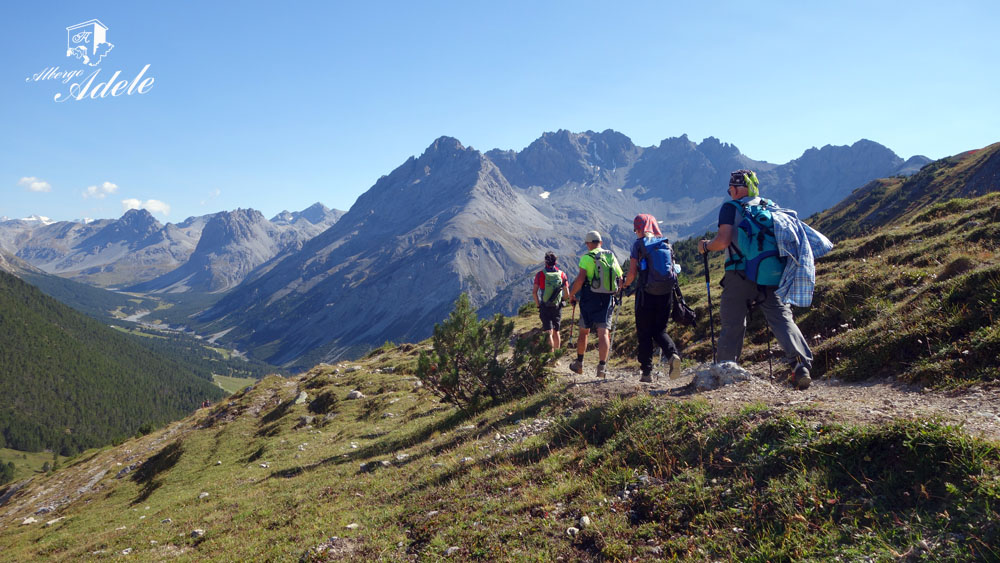
In a bit more than 2 kilometers the road brings you to the locality “Pra Grata”. This section of the route, almost completely going slightly downhill, is marked by the crossing of a wild and isolated valley, enriched by a characteristic wood of alpine pine “Pumilio”, a very rare plant in our regions.
Once you reach the mountain houses and the wide meadow of “Pra Grata” continue on route 182 in the direction of “Alpe del Gallo – Fuorcla del Gal”.
A few minutes walk takes you to the 1860 meters a.s.l of the “Acqua del Gallo” bridge.
Cross the bridge and continue on route 182 in the direction of “Alpe del Gallo – Fuorcla del Gal”.
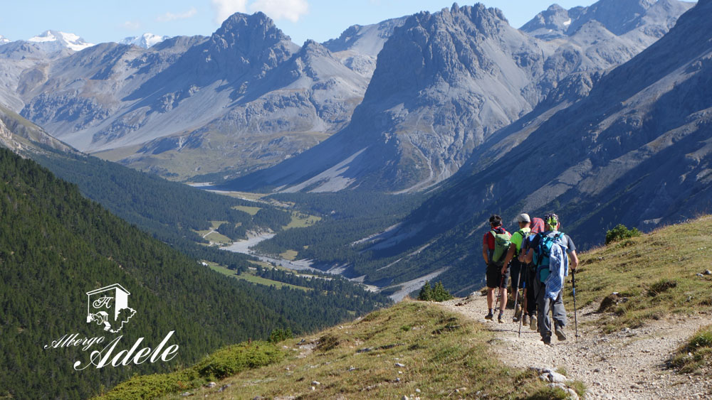
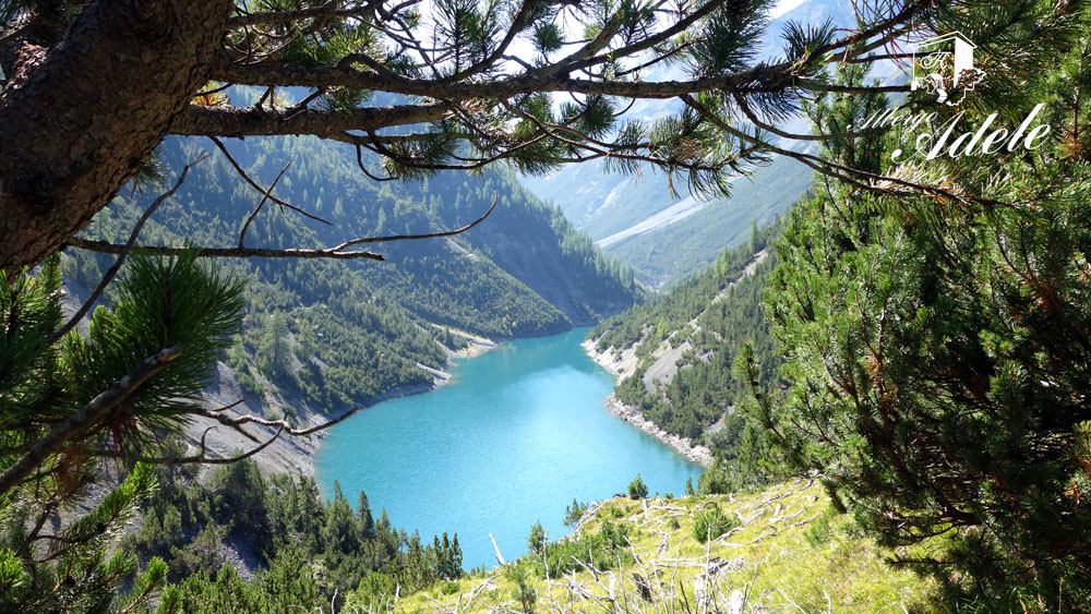
The road, without any difficulties, brings you in view of the long end of the artificial lake of Livigno. The landscape gradually changes and, always in its greatest splendor, gives the impression of a journey around the world, from a primordial North-American valley to the incredible colors of a New Zealand fjord.
Arriving above the lake, the road becomes narrow in some sections and, crossing some streams, presents its only difficult parts.
After these small torrential valleys the track becomes wider.
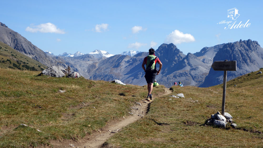
A slight uphill climb marked by some hairpin bends, and surrounded by an enchanted wood, brings you in a few minutes to the ruins of the “Malga Alpe del Gallo” and then, to the “Fuorcla del Gal”. This last one is near the national border between Italy and Switzerland.
A few dozen meters after the border, you arrive at the Gallo Pass and its wide alpine meadow.
Ignoring the trail that goes toward the mountain cottage “Chasa da Cuntin” you should turn right (East) and going slightly uphill continue in the direction of the “Val Mora”.
From the next pass, near a road sign and an incredible panoramic point, the descent starts and, on a steep and ruined single track, in a few minutes brings you toward the heart of “Val Mora”.
Almost at the bottom of the valley, when the downhill track becomes less steep, you have to turn right toward the South-West in the direction of “Paluetta” and the valley toward the lakes of Cancano. You will find this fork a few dozen meters after crossing the torrent that runs down from the pass where you came.
Arriving at the end of the descent, near the river, you will meet the easy trail of Val Mora.
Turn right and following the waters, in a bit more than 5 kilometers and without deviations or difficulties, you reach first the Italian border and successively the “Passo di Fraele”, the start and the end point of our excursion.
The majestic landscape, the peace, the silence, the possibility to see eagles, bearded vultures, deers, chamois and steinbocks, will give you an incredible experience on a route that we reiterate is long, wild and rarely visited by hikers.
Notes:
This excursion runs in one of the less frequented areas of the Alta Valtellina and cellphone signal is almost absent along the entire route. For this reason we invite you to plan the excursion paying careful attention to the weather forecast and the hours of light that you have.
We remind you that almost half route is in Swiss territory
Enjoy your walk!
Stefano and all of the Albergo Adele staff
Text translated by Stefano Bedognè and Paul Faller (teacher at My English Lodi)
COPYRIGHT AND LEGAL POLICIES – UPDATED Mar. 9th 2021
All contents of this blog (text, graphic elements, images, pictures, videos, etc.) are exclusive property of Stefano Bedognè and Albergo Adele s.a.s. and they are protected by Italian and International copyright laws. Therefore only viewing is allowed. Copying, either partial or total, will be allowed only after explicit request and authorization. In this case it must be indicated on the copy the source: www.albergoadele.it. Any other use (distribution or publication for profit, modification, processing in any way or form, etc.) will be considered unauthorized and will be prosecuted by law.
The information provided on this page, on our website and on the blog in general, are finalized to promote the touristic and cultural opportunities of Bormio and Valtellina but they are not substitutions in any way for professional accompaniment or the direct consultation of professional workers.
All of the excursions described on this website are for the purposes of promoting Bormio and Alta Valtellina. Every hiker has to consider independently their physical condition, personal experience and ability. The hiker has to check independently the trail complexity based on personal conditions, trail conditions and weather conditions, including the presence of ice, snow, landslides, avalanches or other events. Albergo Adele and Stefano Bedognè don’t assume any responsibility for any accident occuring to the trekkers during the trip here described. Albergo Adele and Stefano Bedognè always suggest being accompanied by a Mountain Guide.
