
The following proposal is not too difficult an excursion marked by an incredible landscape above the glaciers and over the symbolic mountains of Valfurva. The route runs between the “Val Cedéc” and the “Valle dei Forni”, surrounded by the magnificence of the “Gran Zebrù”, “Cime di Peio”, San Matteo”, “Tresero” and all of the other famous mountains in the area, almost all of them forming a crown around the majestic Forni glacier. The route runs almost completely on single track, far from the noises and chaos of the principal route of the valley.
Rifugio Forni, Rifugio Pizzini, Rifugio Branca
Panoramic excursion with circular route (Valfurva)
#rifugio pizzini #rifugio branca
Total length of excursion: 14211 meters
Total uphill difference in height: 654 meters
Approximate total time needed for the excursion: 5 hours and 30 minutes
Difficulty: easy (4 out of 10)
Recommended season: from the end of June to the end of October (check the altitude of snow before your trip)
Suitable for rainy days? no
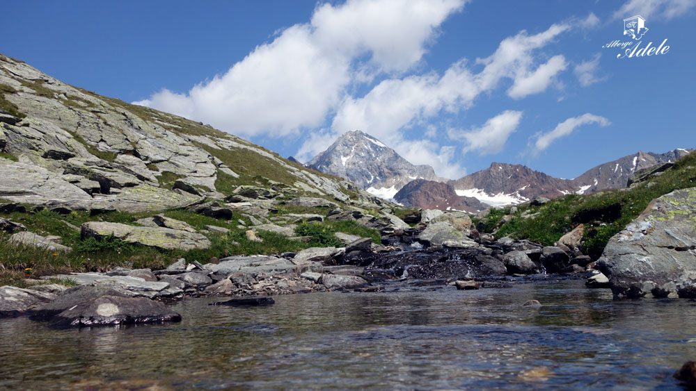
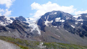
General characteristics of the natural environment: high mountain panoramic excursion with incredible views over the glaciers
Presence of water\fountains on the excursion: yes
Trip on the borders of the Stelvio National Park: yes
Benches on the route: no
Picnic areas on the route: no
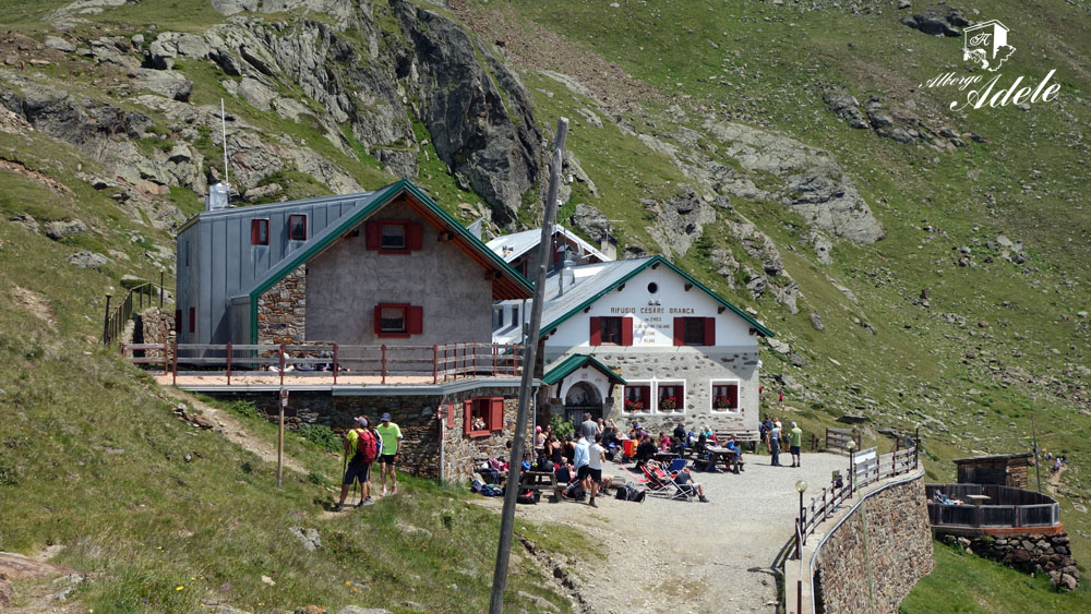
Alpine shelters, bars or restaurants along the route: yes (Rifugio Pizzini – Rifugio Branca)
Circular route: yes
Back and forth route: no
Pushchair accessible: no
Excursion starting point: Rifugio Forni (Valfurva)
Geographic coordinates of the starting point: 46°25’12.43” N – 10°33’19.88” E — UTM: 32T 619532 – 5141903
Altitude of the starting point: 2145 meters asl Maximum height reached on the excursion: 2697 meters asl


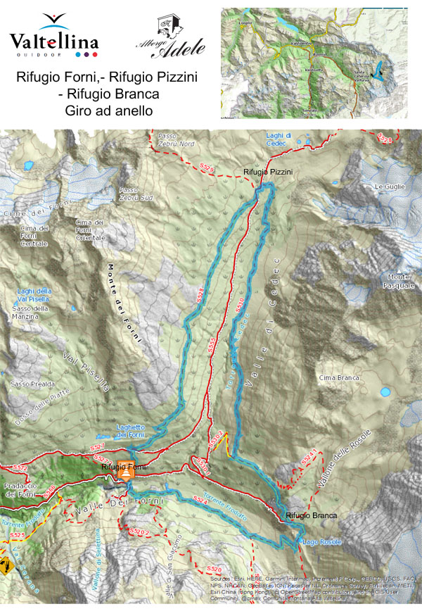
Description of the excursion Rifugio Forni – Rifugio Pizzini – Rifugio Branca
Starting from the “Rifugio Forni” you take the evident stone road that goes uphill in the direction of “Rifugio Pizzini”. A few hundred meters ahead, when you find the second hairpin at the “Baite dei Forni”, you leave the road and follow the panoramic trail 528 towards: “La Caserma (ruins)”.
At the next fork you continue along route 528 in the direction of “La Caserma” and “Rifugio Pizzini”. This section offers an incredible landscape with the “Mount Taviela” and “Cime di Vioz” as the opening stars.
Successively, going up, the panorama is opened also on the other glacial peaks that surround the Forni glacier including “Monte Cadini” and “Monte San Matteo”. Once you reach the ruins of “La Caserma” your ascent is finished. From this point onwards the route, although it has some ups and downs, doesn’t contain any particularly steep or tiring sections.
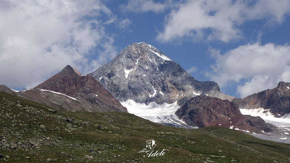
Leaving the trenches and the ruins dating back to the First World War our itinerary proceeds towards the heart of “Val Cedec”, a valley dominated by the peak of “Gran Zebrù”. This famous mountain, called “Konigspitze” in German, is the highest mountain in the whole of “Alta Valtellina” at 3851 meters asl. Its peak, during the White War, was guarded all year round (just a few dozen meters away from each other) by both the Austro-Hungarian soldiers and the Italian Alpini.
Once you reach the “Rifugio Pizzini – Frattola”, after a well-earned break, you restart your walk in the direction of “Rifugio Branca” following route 530 that runs on the bottom of “Monte Pasquale”. This track starts a few meters above the entrance of Rifugio Pizzini. Heading down towards a small wooden bridge you will find yourself in front of the vastness of “Monte Pasquale”. On its left you can see the imposing glacial tongue that descends from the peak of “Monte Cevedale”.
Our excursion proceeds without any difficulties along route 530. When you are more or less at the center of the valley you will find a fork. Here you continue on the left towards “Rifugio Branca”.
From here the track alternates between descents and gentle inclines until it reaches the ridge that separates “Val Cedec” from “Valle dei Forni”.
Here a short ascent with hairpin turns brings you to a fork (not marked by signs) where I suggest you continue on your right. A short downhill tract brings you to a new intersection, this time with road signs. Here you turn left on route 530 in the direction of Rifugio Branca. The track continues flatly towards the Forni glacier with Mount San Matteo at the center of the skyline. Just a few minutes before reaching Rifugio Branca it’s necessary to pay careful attention along a short and exposed section. This tract, in any case, is easy and well signed.
After the break at the shelter you continue along route 524 of “Sentiero Glaciologico Basso”. The track, just a few meters after the shelter, runs up a little bridge beside a resounding waterfall. A short descent takes you to the spectacular little lake of Rosole where, always on route 524 of “Sentiero Glaciologico Basso”, you continue downhill on an easy stone road.
Once you reach the bottom of the valley a nice little wooden bridge allows you to cross the glacial river born of the Forni glacier. Crossing the bridge you turn right and continue on the route 524 in the direction of “Parcheggio Forni”. From this moment onward the track crosses a young wood of larch, birch, fir and rhododendron. This wood, a product of the glaciers shrinking and global warming, was almost completely nonexistent until a few years ago.
Once you arrive at the small dam of “A2a” continue on the flat single track. A few dozen meters ahead, a short uphill section brings you to a fork where you have to turn right. A short descent takes you to the spectacular “scala degli Alpini” (stairway of the Alpini) and from there you will arrive shortly at the nearby “Rifugio Forni”.
Enjoy your walk!


Notes:
- At the end of the excursion we suggest you visit the invaluable Museum of the First World War located inside Rifugio Forni.
- Almost all of the peaks visible along the excursion were guarded 365 days a year by soldiers of both sides during the First World War. On Mount San Matteo, at over 3600 meters, some of the most arduous battles in the Alta Valtellina Area were fought, with a succession of victories and losses on both sides. These mountains, apparently pure and silent nowadays, are a living testimony to the follies of war.
- Along the route it’s possible to find temporary fences for the containment of livestock. We suggest you avoid touching the wire because it is electrified at a low voltage. The potential electric shock, even though it’s not dangerous, is never pleasant.


COPYRIGHT AND LEGAL POLICIES – UPDATED Mar. 9th 2021
All contents of this blog (text, graphic elements, images, pictures, videos, etc.) are exclusive property of Stefano Bedognè and Albergo Adele s.a.s. and they are protected by Italian and International copyright laws. Therefore only viewing is allowed. Copying, either partial or total, will be allowed only after explicit request and authorization. In this case it must be indicated on the copy the source: www.albergoadele.it. Any other use (distribution or publication for profit, modification, processing in any way or form, etc.) will be considered unauthorized and will be prosecuted by law.
The information provided on this page, on our website and on the blog in general, are finalized to promote the touristic and cultural opportunities of Bormio and Valtellina but they are not substitutions in any way for professional accompaniment or the direct consultation of professional workers.
All of the excursions described on this website are for the purposes of promoting Bormio and Alta Valtellina. Every hiker has to consider independently their physical condition, personal experience and ability. The hiker has to check independently the trail complexity based on personal conditions, trail conditions and weather conditions, including the presence of ice, snow, landslides, avalanches or other events. Albergo Adele and Stefano Bedognè don’t assume any responsibility for any accident occuring to the trekkers during the trip here described. Albergo Adele and Stefano Bedognè always suggest being accompanied by a Mountain Guide.
